Tähtitieteellinen yhdistys Ursa
Ilmakehän optiset ilmiöt

Displays
1.4.
The start of April was not very promising. There was a high pressure zone hovering over the British Isles and Central Europe during the very first days of April; those weather conditions brought only a few clouds and halos to observers of those regions. A low pressure region with a jet-stream over Finland brought many clouds, some rain and favoured the extreme North with a few halos. Elsewhere in the Europe it was quiet.
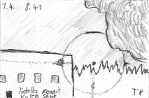
Hence the Savukoski observers Simo Aikioniemi, Ilkka Helenius and Tarmo Palojärvi were obviously the first ones to see halos in this April. The most interesting sight was that of Palojärvi; among the few displays not caused by upper clouds. The groundbound diamond dust crystals rarely manage to create a parhelic circle in Finland. This, however, did happen at Savukoski on the 1st of April.
Satellite image: Apr 1, 11:51+13.31 GMT
2.4.
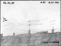
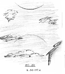
A faint, fragmented sun pillar extended upwards from the sun in the evening in Chemnitz. Gerald Berthold was lucky to see this poetical sight. The drawing Gerald made of this singular pillar is like art ...as if how a faint halo accidentally shows up in the cold world, only to disappear as the sun will soon set.
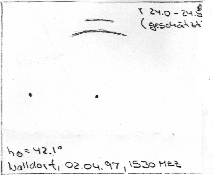
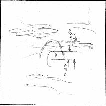
The rarity highlight of the 2nd day came from Central Europe as a strange, short arc above the 22° upper tangent arc made it self apparent for the eyes of Holger Seipelt, the experienced German observer. Anecdotally Seipelt even once visited Finns in the North (during Robert "Bob" Greenler's visit at FHON places) couple of years ago. There are three main possibilities to account for Seipelt's observation: the Parry arc, the 23° parroid (23° parhelion) or a piece of the upper Lowitz arc. Which one was this? In a few cases even photographs do not present accurate enough information to tell the difference. We do not know whether Seipelt photographed the case or not.
Satellite image: Apr 2, 11:40+13:20 GMT
3.4.
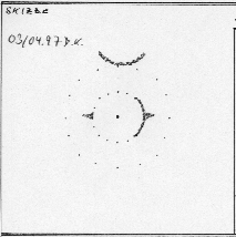
A trough above Southern Scandinavia sent a cold front to Great Britain and later to Central Europe. This was followed by arctic polar air. Ahead of this, several common halos were observed in the Netherlands and Germany. Southern Finland was in the warm sector of this frontal system, so only a few halos were seen there. North of the occlusion lying over Central Finland, some halos occurred. As an example, Paula Sankelo reported one of the low activity displays combined of poorly developed 22° halo and one parhelion. A modest display with the circumzenithal arc greeted Dieter Klatt in Oldenburg, Germany.
Satellite image: Apr 3, 11:29+13:09 GMT
4.4.
The centre of the low pressure area moved across Finland, bringing mostly rainy weather there, but some halos too in the cloud-gaps. Central Europe was behind the cold front. Between snow showers some single halos were observed. North of Great Britain a low pressure area developed, and its warm front curled about England. Les Cowley in Chester, England, took his first halo in April. A parhelion was visible in the early morning.
The first noteworthy display in Finland in April was offered by the same cyclone to Martti Penttinen. Congratulations to Martti! At the time when he was leaving his sauna in Kokkola in the afternoon, he had a glance in the sky. After a while, Penttinen realized there were two elliptical halos around the Sun. "The air was very cold but there were no ice crystals visible," writes Martti. (The crystals had actually been visible in his earlier display of 13.2.1997 that had contained record big ellipse radius. At the same occasion Martti had managed to get the first ice crystal sample of an elliptical halo display). This time the crystal layer might hence have been at the middle level as the situation usually seems to be in cold weather ellipse displays. Typically to elliptical halos, the display evolved very rapidly; sometimes only one ellipse ring was visible. Interestingly, Martti tested the polarization of the halos by rotating the polarization filter in front of the eye. Once again, there seemed to be no effect. Recent ellipse observations seem to give, however, contradicting experiences of the polarization of elliptical halos.
Satellite image: Apr 4, 12:58 GMT
5.4.
Not a good halo day. The British low pressure drifted above Northern Germany and Poland. Finland was located behind the frontal system, and got sparse clouds in mostly sunny weather. Some common halos in Helsinki area and in the North; Jarkko Korhonen got the opportunity to drew parhelia. Ahead of the warm sector only a few halos were seen. A nice circumzenithal arc, slightly covered by low clouds, was however detected by Holger Lau in Pirna in the early morning.
Satellite image: Apr 5, 12:47 GMT
European Halo Project | Contents | Previous chapter | Next chapter
-
 Yksi halomuoto I 4.5.2026 klo 14.02; Kangasala; Jukka Oravasaari
 -
 Yksi halomuoto I 4.5.2026 klo 10.35; Kurikka; Marko Myllyniemi
 -
 Useita halomuotoja II 4.5.2026 klo 8.00-11.05; Saarijärvi; Maritta Kinnunen
 -
 Heijastuneet pilvisäteet II 4.5.2026 klo 6.06; Tampere; Ilpo Hyvärinen
 -
 Yksi halomuoto 4.5.2026 klo 2.10-2.45; Tampere; Tapio Lahtinen
 -
 Maan varjo III 3.5.2026 klo 21.56; Kurikka; Marko Myllyniemi
 -
 Pääsateenkaari III 3.5.2026 klo 21.15-21.25; Lieto; Matti Helin
 -
 Yksi halomuoto I 3.5.2026 klo 20.10; Vaasa; Timo Alanko
 -
 Useita halomuotoja II 3.5.2026 klo 15.19; Eura; Anonyymi
 -
 Yksi halomuoto I 3.5.2026 klo 9.29; Kangasala; Jukka Oravasaari
 -
 Useita halomuotoja II 3.5.2026 klo 5.50-18.55; Turku; Paula Mattila
 -
 Pääsateenkaari IV 2.5.2026 klo 20.45; Kuusamo; Voitto Pitkanen
 -
 Useita halomuotoja II 2.5.2026 klo 17.14-17.22; Orimattila; Pia Simonen
 -
 Harvinaisia halomuotoja IV 2.5.2026 klo 13.26-13.46; Juva; Petri Martikainen
 -
 Useita halomuotoja II 2.5.2026 klo 12.06-12.24; Ruokolahti; Emma Bruus
![[EHP]](fileadmin/_migrated/RTE/RTEmagicC_664970cc8d.gif.gif)
